Zarahemla Magnetometry Scanning and Discovery
The Fires of Zarahemla, 11/27/2020
By John Lefgren, 11/27/2020
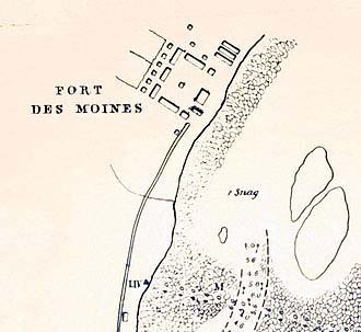 The above map was drawn by Robert E. Lee in 1834 when he came as a young Army officer to deal with the geology of the Keokuk Gorge that stopped riverboats on the Mississippi. Lee came with a company of soldiers. He wanted to determine if it would be possible to create a channel for riverboats to go through the Des Moines Rapids.
From 1834 to 1837, Robert E. Lee and his men built an outpost known as Fort Des Moines No. 1. In 1837 the U.S. Army abandoned the outpost. From 1839 to 1846, Montrose became a landing place for many Mormons who were refugees from Missouri and immigrants from Europe. At first, the Saints lived in Lee’s abandoned barracks. The town soon became known as Montrose. Among the town’s residents were Brigham Young, Wilford Woodruff, and Erastus Snow. Indeed, Nauvoo’s streets aligned to the streets of Lee’s map for Fort Des Moines. For eight years, there were thousands of more Mormons living in Montrose than the town’s current population of 898. Montrose then as well as now had a town area of one square mile or 640 acres. In our research for the Fires of Zarahemla, we scanned the cropland of 21 acres inside the square mile of the city’s limits. Charcoal samples from the ground of this land will be the basis for determining the Carbon-14 dates of the fires.
It seems strange that we have started our detailed search for the City of Zarahemla on a site that Mormons farmed many years before they went to the Salt Lake Valley. It also seems strange that when we look at old maps, we find that the Mormons in the mid-nineteenth century named the very road next to this site as “Zarahemla Road.”
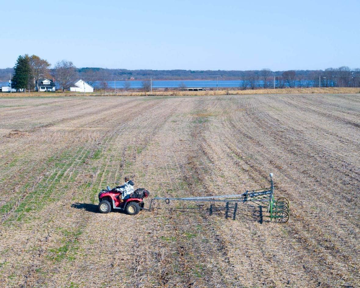
We will take core samples from the ground that the first generations of Mormons farmed more than 150 years ago when they associated the land with the City of Zarahemla. This result was certainly not our intention. We went to the site because it had a cornfield that is well suited for the SENSYS MX V3 scan. Nevertheless, we are grateful that we can start on a site that was part of the Saints’ early history. We take comfort in the fact that we are so close to the faith of the first believers in this Last Dispensation.
The full grid represents an area of about 2.2 acres. Preliminary calculations indicate that there are as many as 124 ancient fires in the ground of this area. Core soil samples will provide pieces of charcoal from the fire pits for which Carbon-14 dating will determine the distribution of the fire pits over a timeline before the arrival of the Europeans to Iowa. The high density of fire pits correlates with a high density of ancient populations.
The assumption is that each fire pit would have represented three people and that one acre of fire pits as found on the grid would have meant a density of populations for hundreds of people per acre over many generations. This result certainly supports the idea that this scanned land was a small part of the Lost City of Zarahemla.
Our magnetic scan showed fire pits and lightning strikes from ancient times. Almost 200 years of farming provided the necessary revenue to protect farmland from development. The cultivation of corn for six generations gave a protective cover for the evidence in the ground. Because of corn, we got the magnetic scans that made it possible to create digital maps that show traces of habitation for an ancient city.
 |
 |
 |
To: Central Lee Community School District
From: John Lefgren
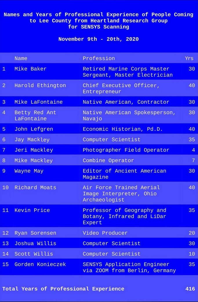 We want to bring to your attention the names and professional experience of the people coming to Lee County to scan 1,000 acres of cropland. We will search for evidence of ancient habitation and activities under the ground’s surface in areas within two miles of the Central Lee Community School District. We have organized our efforts as a serious scientific project involving the talents of 15 people who have more than 400 years of professional experience. We know of no other research project in North America where such a group of talented people has come together to make magnetic scans of lands that will have 6,912 data sets for every square foot of land. A data set will include a super fine measurement of magnetic force (nano-Telsa) with two GPS coordinates (+/- 0.25″) for each point of observation. During the two weeks, we plan to collect, store, and digitally plot about 100,000,000,000 points. The research’s primary focus is to identify variations in the gradients of the nano-Tesla levels to locate fire pits, post holes, roads, and other changes that native people made in the soil as they lived their lives more than a thousand years ago. We believe that the Upper Mississippi and the Des Moines Rapids are significant indicators that an ancient population in Lee county could have been greater than today’s population.
We look forward to meeting the students at your school. We will show them how we can use the world’s best technology as we search about three feet under the ground for data that will begin outlining the pre-European history of your county. The German Company SENSYS has demonstrated the capability of its technology at several sites in Europe and Africa. We are pleased to sponsor the application of this technology in your community. We know that our results will be of great interest and that they will only add to your land’s legacy. …
By John Lefgren, 11/27/2020
Dateline — Montrose, Iowa, November 14, 2020.
Today clear evidence of significant features sprang out of cornfields that are in Montrose, Iowa. The SENSYS MV X3 unveiled from the ground earthworks that date to the timeline of the Book of Mormon.
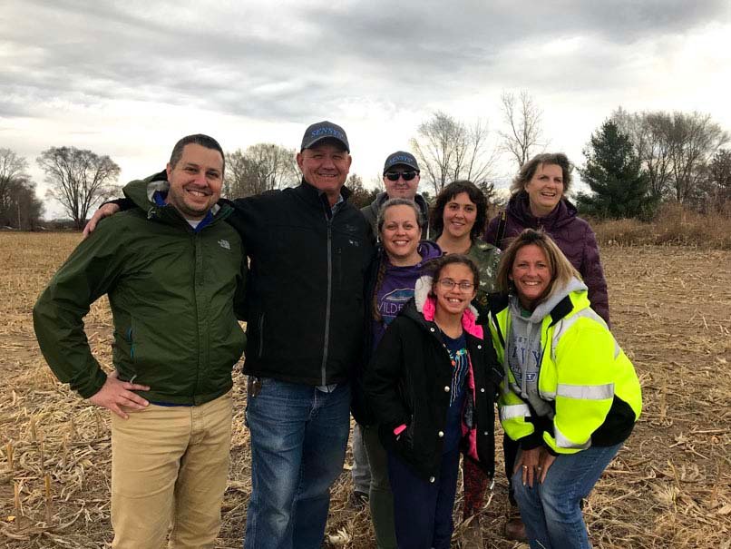
Fourteen people from the Heartland Research Group are involved in this search. Together they have 400 years of professional experience in science, history, digital imaging, and other disciplines.
The new evidence is ancient and significant. The area of interest is more than 200 acres. On Monday the scanning team will continue to make more digital images that will come out of the earth.
Serious students of the Book of Mormon may mark this day as an time when physical truth began to come out of the earth to confirm the existence of the Great City of Zarahemla.
Doubters may replace doubts with faith. Mockers will have a hard time to explain what until now was unseen in the ground for thousands of years.
The Heartland Research Group is more than pleased with the results of today’s scans. We have spent years looking for such results. We have traveled the world looking for the right combination of technology and place. Today they came together. Tomorrow the truth will spring out of the earth in greater abundance.
Praise God from Whom all blessings flow.
 |
|
|
|
|
|
|
|
|
|
|
|
|
|
|
|
|
|
|
|
|
|
|
|
|
|
> |
|
|
|
|
|
|
|
|
 |